Ranked #1 on the 2025 Climate Risk Index. $15B in 2022 flood damages alone. The same storms bypass a terrain that stopped being able to catch them.
Years of ERA5 record behind the physics
Intelligence layers, one convergence map
Countries in active fieldwork
The intel layer for governments, multilaterals, and the capital that funds water, restoration, and carbon projects. When pressures converge in the same district, interventions stop being scattered — they start compounding.
No more guesswork. No more picking sites by availability or politics. When you can see where multiple pressures and opportunities overlap, every dollar, every tree, every tonne of biochar goes exactly where it does the most.
A district with high fertilizer costs, available crop residue, and declining water tables is not three problems. It is one site where biochar cuts input costs, builds soil, and restores water. The overlap is the leverage.
The same tight coupling that lets degradation cascade through a landscape can be reversed. Restore the right site and the effects travel: downstream water quality improves, adjacent farms see moisture return, the atmospheric signal shifts.
Pakistan is not short on data, money, or people who care. It is short on a view that shows where all of these meet. The crises are real. So is the opportunity hidden inside them.
Pakistan uses more water per hectare than almost any country in its income bracket. Efficiency gains in agriculture are water gains for everyone.
Farmers in high-input districts spend PKR 12,000-18,000/acre on synthetic fertilizer. Every rupee exposed to exchange rate risk and commodity swings.
Rice straw in Sindh and Punjab. Sugarcane tops in lower Punjab. Feedstock for biochar, compost, and energy, set on fire every harvest.
The same Indus floodplain that grows Pakistan's food absorbed a catastrophic flood. Recovery siting needs spatial intelligence, not guesswork.
Between the Arabian Sea and K2, Pakistan's terrain intersects five successive condensation stages. A single atmospheric variable, the lifting condensation level, decides how many are active. Across 45 years of ERA5 reanalysis, the answer is two. The other three are not blocked by geography. They are compressed by a missing land surface. That compression can be released.
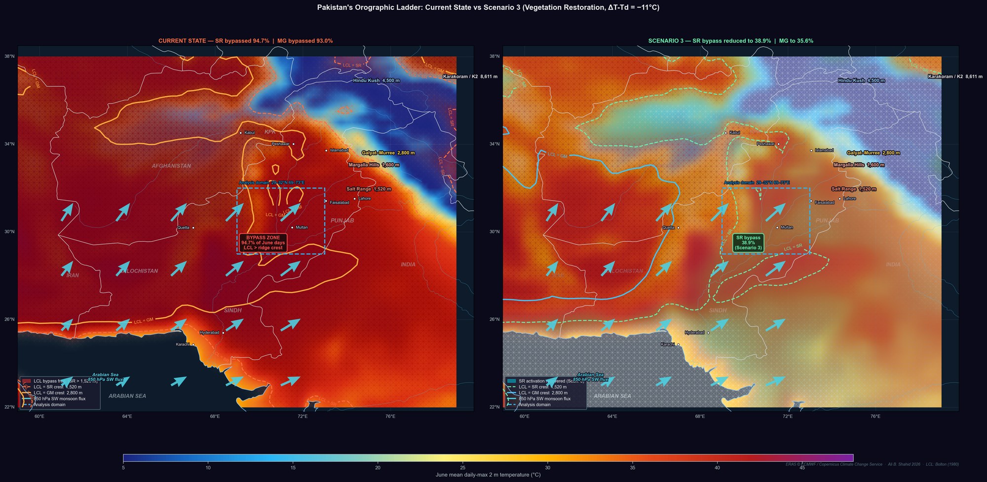
The gap between Pakistan's current water capture and its terrain-defined ceiling is the largest unrealized natural capital endowment in South Asia. Closing it is a water-security, food-security, and climate-resilience problem solved by the same intervention.
Each layer is a spatial question with a spatial answer. Select one to read what that answer looks like, per district, per season.
Where do all seven answers point to the same coordinates?
A single pass of the stack surfaces where the basin’s coupling is tight enough to carry a cascade. The deliverable is an optimization — trigger points ranked by leverage per dollar, each with its intervention, its cost, and the positive trajectory it unlocks. Indicative map below; real engagements deepen the layer set, re-weight for the client’s question, and ground-truth every candidate before a dollar is committed.
Satellite runs always. Field closes the gap satellite can’t resolve. Bespoke answers the question the standing stack wasn’t built for. All three feed the same leverage map.
Continuous, audit-grade remote sensing across the full intelligence stack — country or basin scope, repeatable cadence, physics that survives review.
Drone, LiDAR, soil, and acoustic baselines at the sites satellite flags but can’t verify. Closes the gap between 10 m pixels and a foot on the ground.
Custom analysis, modelling, and dataset generation when the standing stack doesn’t answer what you’re defending. Transferable, reproducible, yours.
Pakistan is the flagship — deepest data, longest record, most published. The pattern repeats wherever terrain, water, and land-surface coupling form the primary constraint.
Twenty years in systems engineering. A decade on coupled land–atmosphere systems. Peer-reviewed work in hydrology and thermal forcing. Active projects across six countries. LandIQ is the instrument for locating where restoration carries furthest.
Entrepreneur with a thirty-year track record of executing first-of-kind projects in industry and capital — from a patented textile-wastewater reuse process (PK 139309, 2007) to leadership of the Indus Climate Fund in New York, directing catalytic capital into climate technology, sustainable agriculture, biochar, and carbon markets. Trustee of the Irshad Foundation for nineteen years, financing girls’ education across rural Sindh. Stony Brook University. Anchors LandIQ’s operational scale, client relationships, and long-term direction as the practice moves from consulting to platform.
Every degraded landscape contains the map of its own recovery. The coupling that drove collapse is the same coupling that carries restoration. The question was never whether recovery is possible. It was always: where do you start?
Featured on Investing in Regenerative Agriculture as "one of the few who can model and calculate water cycle restoration."
Today, each engagement is bespoke. The pipeline that backs them becomes a product once the pipeline is proven.
Spatial intelligence assembled per-project. Satellite-based analysis, convergence reports, strategic plans, and advisory engagements across water, agriculture, and restoration.
Automated ingestion from satellite, government, and field sources. Convergence scoring validated against live deployment outcomes. Bioacoustic biodiversity layer in development.
Self-serve access. Query any district. Export convergence reports. API for MRV integration, carbon registries, and project developers.
We work with organizations, governments, and investors who want their next intervention to land at the site where one action carries five outcomes.
ali@landiq.earth